Scenic Rim West: Walking Tours, Mountain Trails & Main Range
Scenic Rim West: Walking Trails, Mountain Hikes and Main Range Wilderness
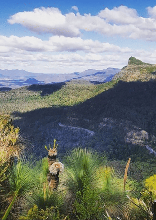
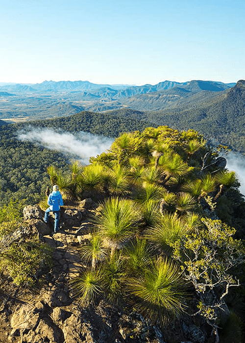
Scenic Rim West walking offers some of Australia’s most rewarding trails. The western reaches of the Scenic Rim are where the landscape shows its geological character most clearly. Impressive mountain peaks, escarpments, and ridges offer breathtaking views within a World Heritage Area that is home to rare and endangered wildlife. This is a popular destination for walking tours and bushwalking for good reason—the landscape rewards the effort of ascent with perspective that changes how you see the terrain below and the continent beyond.
Wander is positioned at the hub of the mountain range that forms the namesake of the region, making us an ideal base camp for day trips into the wilderness. Head west toward Boonah and through beautiful rural country to reach Main Range National Park and its attending trails. The Scenic Rim region is vast, so we recommend allowing a full day for each direction you explore. Take your time. There are treasures to discover and stories to encounter along the way.

Mount French: Two Tracks with Big Impact
Logan’s Lookout (North Cliff Track)
This track leads to Logan’s Lookout, offering excellent panoramic views over the Fassifern Valley. To the west lies the Main Range escarpment; to the east, Flinders Peak and beyond. This is a formed track with gentle hills, suitable for wheelchairs and prams—accessibility without sacrificing beauty. The viewpoint overlooks farmland interspersed with native bushland, showing how rural communities share the landscape with protected wild areas.
Distance: 720 metres return Time on trail: 15 minutes Skill level: Easy Facilities: Flushing toilets, wood BBQs, picnic tables Best season: Year-round; clearer views in autumn and winter
Mee-bor-rum Circuit
This circuit track moves through open forest and rocky outcrops, featuring the East Cliff lookout with views of Tamborine, Lamington, and Mount Barney. Further along, a circular platform with seating provides views across heathland and the southern side of Mount French. The track itself is more challenging—formed but with short steep sections, rough surfaces, and many steps.
The heathland visible from this vantage point is an important ecological community. It supports specialised plants adapted to poor soils and frequent disturbance, including many endemic species found nowhere else. In spring (September–November), wildflowers transform this landscape into a botanical garden.
Distance: 840 metres return Time on trail: 25 minutes Skill level: Moderate Best season: Spring for wildflower colour; autumn for comfortable temperatures
Together, these two walks offer versatility. Arrive early, complete both trails at your own pace, and settle into the landscape’s rhythm.
From Wander: 35km, 32 minutes Location: The end of Mount French Road, Boonah
Mount Cordeaux: Rainforest to Exposed Ridge
The cliff face of Mount Cordeaux is particularly spectacular in spring when giant spear lilies flower, creating a botanical display amidst the stone. These lilies are endemic to the region and serve as a visual marker of the transition zone between rainforest and exposed rocky peak. The landscape is alive with birds and wildlife—watch for lyrebirds mimicking other species, and listen for the call of the rarely-seen Paradise Riflebird.
For those with additional energy and time, pushing on to Bare Rock adds 3.2 kilometres to the walk but offers another stunning lookout over the fertile valleys of Tarome. The view from Bare Rock is worth the extra effort. On clear days, this vantage point reveals the geological structure of the entire Main Range, with layers of ancient rock exposed in the cliff faces.
Distance: 6.8km return (plus 3.2km with Bare Rock) Time on trail: 2.5–5 hours depending on whether you include Bare Rock Skill level: Moderate—formed track with steep sections, rough surfaces, many steps From Wander: 60km, 50 minutes Location: Top of Cunningham’s Gap, turn right into The Crest carpark adjoining the highway Note: Water sources are limited; bring at least 2 litres per person
Mount Mitchell: The Half-Day Summit
The natural lookout here is extraordinary. From this vantage point, you can see across the Fassifern and Millar Vale Creek valleys. Mounts Maroon, Lindesay, Barney, and Ballow form the distant landscape. You feel genuinely on top of the world here—a feeling that perspective and effort have earned.
Search the sky for Peregrine Falcons, which can reach speeds of up to 180 kilometres per hour in near-vertical hunting dives. Watching these birds navigate the cliff face with such precision is a reminder that the landscape belongs to creatures whose relationship with it is far older and more intimate than ours. Other raptors including Wedge-tailed Eagles also hunt from these high ridges.
The montane heath environment at this altitude is particularly fragile. Stay on marked tracks to protect rare alpine vegetation that takes years to recover from trampling.
Distance: 10.2km return Time on trail: 3 hours Skill level: Moderate—rough track with long, steep sections From Wander: 60km, 50 minutes Location: Top of Cunningham’s Gap, turn right into The Crest carpark adjoining the highway Note: Weather changes rapidly at altitude; bring layers and check conditions before starting
What to Bring for Scenic Rim West Hiking
Include a broad-brimmed hat, sunscreen, and insect repellent. The elevation means UV exposure is more intense. Bring snacks and a simple lunch. Finally, bring a headtorch or torch if returning after dark, which happens early in cooler months.
When Is the Best Time to Hike the Western Scenic Rim?
What Is There to Do in the Scenic Rim West?
Where Can You Eat Well in the Western Scenic Rim?
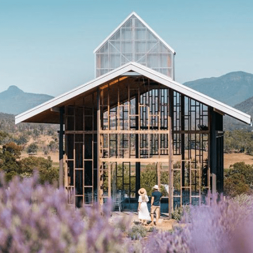
Kooroomba Vineyard and Lavender Farm
Kooroomba is home to a cellar door, restaurant, and lavender shop, overlooking six hectares of vineyard and breathtaking lavender fields. This is a Southern France experience set in the Scenic Rim—unhurried, beautiful, and genuinely restorative. Executive Chef Daniel Groneberg’s food celebrates fresh ingredients and reflects the rustic simplicity of French country-style cooking.
This is a place designed for unrushed lunch and magnificent views of the Great Dividing Range. The lavender blooms in spring (September–November), creating purple seas that shift in the changing light.
From Wander: 62km, 55 minutes Address: 168 FM Bells Road, Mount Alford Hours: Wednesday–Sunday 10am to 3pm
The Peak: Wilderness Dining
Perched on a mountaintop and enveloped by a World Heritage listed National Park, The Peak is an exceptional dining experience. Head Chef Dean Alsford is passionate about showcasing the best of Australian produce—not just the food itself, but the farmers who grow it, the plates it’s served on, and the people serving it.
With an open stone fireplace, captivating views, and luxury dining, this is perfect for a romantic evening or a special occasion gathering. The landscape provides the context; the food honours the landscape. Booking is essential, particularly for dinner.
From Wander: 78km, 1 hour 18 minutes Address: 1 Wilkinson Road, Maryvale
The Scenic Rim Farm Shop
A café and produce shop nestled under towering Jacarandas and surrounded by working farms. Enjoy local coffee and food prepared by Kate Raymont with ingredients from the Scenic Rim itself. While you’re there, visit Elderflower Farm, a boutique flower farm and florist run by Fred and Rachel Watkins. They sell fresh-cut heirloom flowers grown on site and a selection of beautiful garden goodies.
This is a place where the connection between landscape, farming, and food is visible and honoured.
From Wander: 38km, 32 minutes Address: 541 Kents Lagoon Road, Kalbar Hours: Friday–Sunday 8:30am–4pm
Walking the Western Rim with Intention
Come with proper footwear and water. Check conditions before setting out. Allow time for the walk itself, not just the destination. The paths between viewpoints are part of the experience—the forest you move through, the sound of wind through the ridge, the light changing as altitude increases.
The western Scenic Rim will reward your care with perspective that lasts long after you return home.
About the Author
Cassandra Sasso is the Founder and CEO of Wander, Australia’s leading regenerative travel brand. With a deep belief that travel can transform our relationship with country, community, and self, Cass established Wander to redefine what luxury and purpose in travel means. She writes about slow travel, sustainable design, connection to Country, and the art of living with intention.
Ready to experience the Scenic Rim for yourself?
Explore Wander in the Scenic Rim and find your place in nature →
Continue Reading:
Wild Swimming in the Scenic Rim
In Queensland’s Scenic Rim, the swimming holes are not conveniences—they are destinations. Cedar Creek Falls cascades through Tamborine
Explore the Scenic Rim: Green Mountains
The Green Mountains section of Lamington National Park sits at the heart of the Gondwana Rainforests of Australia — a World Heritage Area defined by