
⸻ SCENIC RIM, QLD · FIELD NOTES
Wild Swimming in the Scenic Rim: The Best Swimming Holes, Lakes and Waterfalls
Cold water, clear light, and the slow art
of getting in.
The Scenic Rim's wild swimming holes are not busy pools with a lifeguard chair and chlorine smell. They're fresh creeks and rock pools fed by rain and mountain runoff, cool enough to make you gasp, and mostly reached on foot rather than by car park. For those who'd prefer not to walk, this guide also covers the region's lakes: one has a designated swimming area you can drive straight to, and the other two are better for a paddle or a boat than a swim. None of them are staffed, none are heated, and most will leave you feeling more alive than you've felt for a long time.
This guide covers the best spots: Tamborine Mountain, Lamington foothills south of Beaudesert, Mount Barney, and the biggest lakes of the Scenic Rim. Pick one and give it a proper afternoon rather than trying to see all of them in a day.
In this entry
8 sections
The short version
- Choosing where to swim
- Tamborine Mountain: Cedar Creek Falls, Curtis Falls
- South of Beaudesert: Christmas Creek, Larapinta Falls
- Mount Barney: Lower Portals, Waterfall Creek Reserve
- Scenic Rim Lakes: Lake Wyaralong, Lake Moogerah, Lake Maroon
- Water safety and what to bring
- Common questions
- Where you'd stay
The water doesn’t care that you had a hard week.
That's why it works so well.
Choosing where to swim
The spots below sit in different corners of the Scenic Rim, and they're not close together. Cedar Creek Falls and Curtis Falls, on Tamborine Mountain, sit apart from the rest, to the north of the region. Christmas Creek and Larapinta Falls are in the Lamington foothills south of Beaudesert, and Lower Portals and Waterfall Creek Reserve are in Mount Barney country nearby. Lake Moogerah and Lake Maroon both sit near Boonah, and Lake Wyaralong is closer again, right at the WanderPods themselves. Exact drive times from the WanderPods to each of these are worth checking before you commit a day to any one of them.
01
Tamborine Mountain

Cedar Creek Falls
Cedar Creek Falls, in the Cedar Creek section of Tamborine National Park, is the mountain's one currently permitted swimming spot. Curtis Falls, covered separately below, is the better-known of the mountain's two waterfalls, but it isn't open for swimming.
The track to the pools is 1.1km return and takes around 30 minutes, graded 3 (moderate) by Queensland Parks: a good number of steps down through eucalypt and rainforest, and the same steps back up on the way out. The pools are unpatrolled, and Queensland Parks is direct about it: swim at your own risk, and don't jump or dive, since serious injuries have happened here. Glass containers aren't permitted in the gorge area either.
The carpark on Cedar Creek Falls Road is small, and Queensland Parks currently has an alert out for limited parking, so arrive early on a weekend. The water is cold whatever the season, and the walk back up is steeper than it feels on the way down.
Walking track
1.1 KM · 30 min
From Wander to start point
42km· 40 MIN
TYPE
CREEK-FED

Curtis Falls
Curtis Falls, in the Joalah section of Tamborine National Park, is the mountain's better-known waterfall and the one most people searching for Tamborine's waterfalls actually mean. It isn't a swimming spot. Queensland Parks prohibits access to the rock pool and the surrounding area at all times, to protect a resident glow-worm colony and the local platypus population, and penalties apply for entering beyond the viewing platform.
The track from the Dapsang Drive car park is 1.1km return, graded 3 by Queensland Parks: wet eucalypt forest and rainforest leading to a viewing platform, where water drops over columnar basalt rock into the closed-off pool below. Turtles, fish and eels are visible from the platform, and the surrounding cliffs hold a glow-worm colony that's visible after dark, though the track itself isn't lit for a night walk.
If you want a swim on Tamborine Mountain, Cedar Creek Falls, covered above, is the currently permitted spot.
Walking track
1.1 KM · 30 min
From Wander to start point
46km· 45 MIN
TYPE
CREEK-FED
02
Lamington National Park

Christmas Creek
Christmas Creek sits south of Beaudesert, in the foothills below Lamington National Park, and it's a quieter proposition than Cedar Creek in almost every way. The walk in, often called the Westray's Grave track, starts at a small carpark at the end of Christmas Creek Road (room for around ten cars) and crosses private farmland before entering forest, so close the gate behind you.
It's 7.5km return, and allow 3 to 4 hours. The track isn't a formed national park path and carries no official Queensland Parks grade, but it demands real bushwalking experience: one creek crossing that's straightforward when the creek is low and considerably harder after rain, some rock scrambling, and track markers that are genuinely easy to miss. Rock pools and small cascades appear along Christmas Creek well before you'd need to commit to the full return trip, so a shorter out-and-back for a swim is a reasonable option too.
The track passes Westray's Grave, the resting place of James Westray, a passenger from the 1937 Stinson airliner crash in Lamington National Park. Westray left the wreckage to find help for the other survivors and died before he could reach it; he's buried close to where he was found, by the creek. It's a quiet, mostly unmarked piece of history, and it changes how the walk feels.
Walking track
7.5 KM return · 3-4 hr
From Wander to start point
62km· 55 MIN
TYPE
CREEK-FED
Larapinta Falls
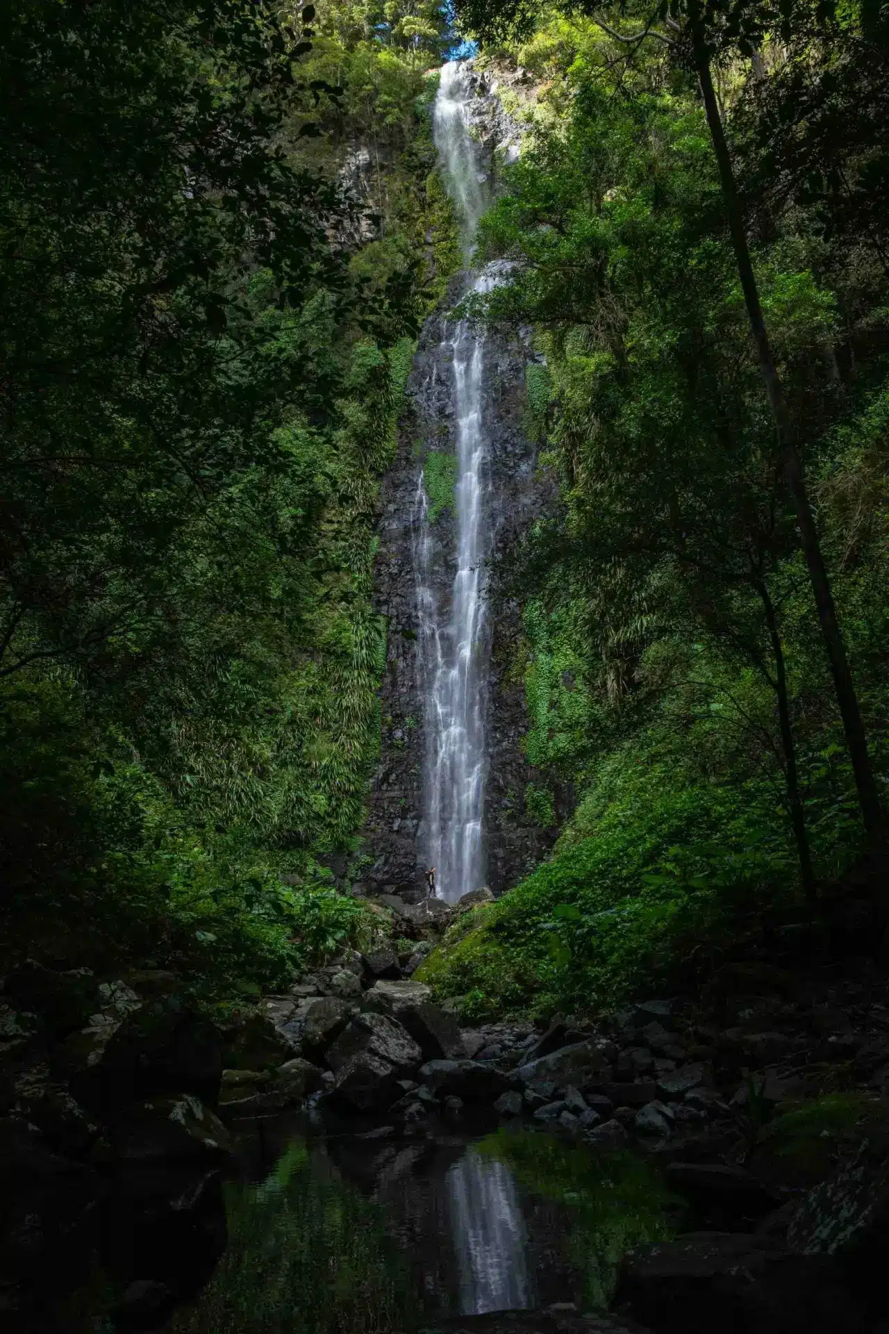
Larapinta Falls sits further up the same track as Westray's Grave, so if you're already walking in to Christmas Creek, it's an extension of that day rather than a separate trip. Past the grave, the trail keeps following Christmas Creek upstream to a waterfall reported at more than 30 metres, dropping into a pool wide and deep enough for a proper swim. Independent hikers who've made it describe it as one of the better waterfalls in the wider Lamington area, though it isn't named or signposted by Queensland Parks.
That absence is the point. Queensland Parks doesn't grade this stretch at all: officially, the ground past Westray's Grave sits off the formed track network entirely, the same unmarked route the department lists as the access path to its Stinson and Point Lookout remote bush camps, and it describes that route as suitable for "fit, experienced, self-sufficient hikers" only. Hikers who've reached the falls report further creek crossings and rock scrambling beyond the grave, faint markers, and sheer rock near the falls themselves, where a slip carries real consequences. Keep well back from the edge, supervise anyone with you closely, and don't take this on without genuine bushwalking experience and a full day in hand.
Distances reported for the return trip from the Christmas Creek car park vary by source, from around 8km to 10km, with walking times reported from 5 to 8 hours. Treat both as estimates rather than fixed figures until confirmed, and plan for a full day rather than an afternoon addition to the Christmas Creek walk.
Walking track
8-10 KM · 5-8 hr
From Wander to start point
62km · 55 MIN
TYPE
CREEK-FED
03
Mt Barney

Lower Portals
Lower Portals, in Mount Barney National Park, is the one genuine hike on this list, and the reward at the end is proportional to the effort. The 7.4km return track climbs and drops through eucalypt forest and grass trees, crosses Mount Barney Creek twice on rock, and finishes at a deep pool set inside a rocky gorge.
Queensland Parks grades it 4: moderate to steep in sections and genuinely rough underfoot, with about 3 hours needed. Follow the trail signage carefully after the second creek crossing, since it's easy to lose the track there, and keep a close eye on kids at the pool itself. It's deep, and the surrounding rock is a serious drop in places.
Queensland Parks recommends walking Lower Portals in the cooler months, April to September, and steering clear of it altogether after heavy rain, when the creek crossings turn genuinely dangerous rather than merely inconvenient.
Walking track
7.4 KM return · 3 hr
From Wander to start point
60 km · 1 hr
TYPE
CREEK-FED

Waterfall Creek Reserve
Waterfall Creek Reserve, near Maroon, is the quietest and least developed of the spots. It's a basic camping ground beside a permanent waterhole set beneath rock walls, with a waterfall that runs properly after rain and drops to a trickle in dry spells. Reports on facilities genuinely vary, some list toilets on site, others describe it as bring-your-own-everything, so plan as if there's nothing there and treat anything you find as a bonus.
This part of the Scenic Rim, close to Mount Barney National Park, sits within an active recovery area for the brush-tailed rock-wallaby, one of the region's rarer residents.
Walking track
from the camp ground
From Wander to start point
46 km · 54 MIN
TYPE
CREEK-FED
04
Scenic Rim Lakes

Lake Wyaralong
Lake Wyaralong is the body of water the WanderPods in the Scenic Rim look out over, so if you're staying there, it's already at your door. Paddling is what the lake is actually set up for: kayaking, canoeing and rowing are all permitted, alongside electric-powered boats and sail craft, and it's popular enough locally to host rowing regattas. For swimming, Lake Moogerah below is the better bet; this one's built for getting out on the water rather than into it.
Launch from the Meebun Recreation Area, off Beaudesert-Boonah Road, where there's a boat ramp, kayak and canoe access, picnic tables and a playground. On-water access runs 6am to 6pm, and no boating permit is required. The area is only serviced by tank water, so bring your own drinking water. Check Seqwater's site for current access notices before you go, since a secondary canoe access point off Knehr Road has had temporary closures.
distance from carpark
0 KM
From Wander to car park
5 km · 5 MIN
TYPE
dam

Lake Moogerah
Lake Moogerah, on Reynolds Creek near Boonah, is the largest lake in the Scenic Rim and the one Seqwater has actually set up for swimming. The designated area is at AG Muller Park, off Muller Park Road, marked with buoys and open to the public seven days a week. There's no lifeguard on duty, so the usual rules apply: swim within the marked area, and supervise kids closely.
Moogerah is also the lake for everything else: canoeing, kayaking, sailing, fishing with a permit, and motorised boating and water skiing elsewhere on the lake, so expect more activity and more people than the creek-fed spots elsewhere in this guide. Seqwater does close the swimming area from time to time for water quality or maintenance, so check their site before you drive out.
distance from carpark
0 km
From Wander to carpark
43 km · 35 MIN
TYPE
dam

Lake Maroon
Lake Maroon, on Burnett Creek south of Boonah, is the highest-octane of the three lakes in this guide. Seqwater permits water skiing, jet skiing, wakeboarding and tubing here, alongside canoeing, kayaking, rowing and sailing, so expect a busier, faster stretch of water than Moogerah or Wyaralong.
Seqwater's own recreation land still has no designated swimming area, the same as Wyaralong. But Lake Maroon Camping Ground, a private holiday park on the lake's edge, opens its lakeside beach to day visitors for a small fee, and swimming is one of the things that fee covers, along with launching a boat and using the park's toilets, showers and kiosk. Visitor numbers are limited on busy weekends and school holidays to leave room for camping guests, so call ahead rather than just turning up.
The public boat ramp is at Slater Park, off Slater Park Road, and the Maroon Dam Day Use Area, off Maroon Dam Road, has picnic tables, BBQs, a playground and is the only spot on the lake where dogs on leash are permitted. Fishing needs a permit. Wear a lifejacket if you're on the water, and keep clear of the dam wall and other lake users, since this lake sees genuine boat traffic.
distance from carpark
0 km
From Wander to carpark
55 km · 45 MIN
TYPE
dam
Water safety and what to bring
None of these swimming spots are patrolled. Queensland Parks is explicit about the ones on national park land: enter gradually rather than diving or jumping, since the bottom is often shallower or rockier than it looks, and stay out altogether if the water's moving fast or still rising after rain. Flash flooding is a real risk in this landscape, and a swimming hole that's calm on a dry afternoon can turn dangerous within hours of a storm. At Lake Moogerah, stay inside the marked buoys and check Seqwater's alerts for temporary closures before you go. If you're paddling at Lake Wyaralong, wear a life jacket and launch only from the Meebun Recreation Area; the lake shares water with electric boats and rowers. At Lake Maroon, wear a lifejacket on the water and stay clear of the dam wall, since this lake carries genuine boat and jet ski traffic.
Don't swim alone. Tell someone where you're going and when you expect to be back, particularly at the quieter spots like Christmas Creek and Waterfall Creek Reserve, where mobile reception is patchy at best.
Wear shoes that can get wet. Old runners or dedicated water shoes make the difference between an easy scramble over creek rocks and a cut foot. Wipe off sunscreen and insect repellent before you get in if you can, since both leave a film on water that's otherwise clean. Bring more drinking water than you think you'll need for the walking spots, a towel that dries fast, and a dry bag for your phone and keys.
Common questions
Which of these is best for a first visit?
Cedar Creek Falls, if you want a short walk and don't mind company; it's the most accessible and the best-known. Lake Moogerah, if you'd rather not walk at all. Save Lower Portals and Christmas Creek for a day when you've got several hours and proper shoes.
Are any of these good for kids?
Cedar Creek Falls works for older kids who can manage steps, but the pools need close supervision rather than being shallow-water friendly. Lake Moogerah's designated swimming area is the most straightforward option for families, with buoys marking the swim zone and no walk required, though there's still no lifeguard on duty. Lower Portals and Christmas Creek suit older kids and teenagers with some walking experience behind them.
Is the water actually safe to swim in?
It's natural water, not a treated pool, and none of it is patrolled. Water quality is generally good across the Scenic Rim's creeks and rivers, but conditions change fast after rain. Queensland Parks recommends checking current alerts and avoiding these spots for a day or two after heavy rainfall, when runoff and fast currents are the real risk.
When's the best time of year to go?
Lower Portals is specifically recommended in the cooler months, April to September, when the walk is more comfortable and the water more predictable. Cedar Creek Falls runs cold year-round, so summer is when most people actually want to get in. Lake Moogerah's swimming area sometimes closes temporarily, so check Seqwater's alerts regardless of season. Waterfall Creek's waterfall needs recent rain to run properly, so aim for spring or winter if seeing it flow matters to you.
Do I need to book ahead for any of these?
No. Cedar Creek Falls, Christmas Creek, Lower Portals, Waterfall Creek Reserve and Lake Moogerah's designated swimming area all sit on public national park or reserve land, so no booking is required, just genuine care with conditions, the track itself, and a check of Seqwater's alerts for Lake Moogerah.
What if I can only get to one?
Pick based on how much walking you want. Lake Moogerah if you want water with minimal effort. Cedar Creek Falls if you want a short, well-known walk. Lower Portals or Christmas Creek if the walk itself is part of what you're after, not just the swim at the end.
Can I do Christmas Creek and Larapinta Falls in the same day?
Only if you've got the fitness, the daylight and a full day free. Larapinta Falls is reached by continuing past Westray's Grave along the same track, not a separate walk, so it's the same day rather than a second trip. But doing both adds several hours and a harder, unmarked stretch onto what's already the toughest of the featured spots. If you're not certain, stop at Westray's Grave.
Can I swim in Lake Wyaralong from the WanderPods?
There's no designated swimming area, so Lake Moogerah is the better call for an actual swim. Wyaralong is better used for a paddle: launch a kayak or canoe from the Meebun Recreation Area instead.
Looking for where to stay in the Scenic Rim?
- LOCATION
stay with us
Find your time to Wander.
Architect-designed, off-grid, Certified B Corporation.
Ten dollars of every direct booking supports Bush Heritage Australia.
Stay a few nights and let the days lengthen.
Continue reading

Destination Guide · Scenic Rim
The Scenic Rim by Town: Boonah, Beaudesert, Canungra and Tamborine

Destination Guide · Scenic Rim
Bringing your dog to the Scenic Rim: A Complete Guest Guide

Destination Guide · Scenic Rim